|
This page is for monitoring local
weather for outdoor activity or Spotter tracking. DO NOT use this page
as your sole weather information. You should monitor local weather
services on approach of severe weather. Have a Lightning Safety Plan.
________________________________________________________________________________________
Read NWS
WFO-Miami Issued Advisories
Coastal
Palm Beach
Metro
Palm Beach
In-Land
Palm Beach
Glades
Hendry
Martin
Coastal
Broward
Metro Broward
In-Land Broward
Metro Miami
All
NWS Florida
WARNINGS
Click
Here
____________________________________________________________________
Text
Forecast Information
South
Florida Weather Forecast:
From
NWS WFO Miami
|
|
Live Local NOAA
All Hazards Radio
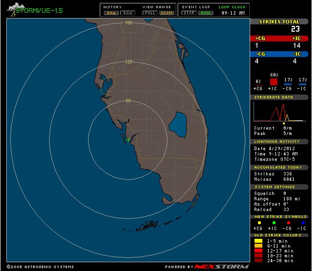
Lightning Radar
Aviation Weather

Click
Picture
Pilot Weather

Click
on Picture
Clewiston Skydiving
Lightning Safety
Tips
NWS
Outdoor Safety Check List
You are not
safe anywhere outside.
Run to a safe building or
vehicle when you first hear thunder, see lightning or observe
dark threatening clouds developing overhead.
Stay inside until 30
minutes after you hear the last clap of thunder.
Do not shelter
under trees.
Plan Ahead!
- Lightning can and does
strike the same place more than once.
- Lightning can strike approximately
8-10 miles ahead or behind a storm.
- Do not use corded
appliances or phone during storm.
If no shelter available,
these actions may slightly reduce your risk of being
struck by lightning:
- Avoid open fields, the
top of a hill or a ridge top.
- Stay away from tall,
isolated trees or other tall objects. If you are in a
forest, stay near a lower stand of trees.
- If you are camping in
an open area, set up camp in a valley, ravine or other low
area. Remember, a tent offers NO protection from lighting.
- Stay away from water,
wet items (such as ropes) and metal objects (such as fences
and poles). Water and metal are excellent conductors of
electricity. The current from a lightning flash will easily
travel for long distances (See Figure 2 below).


US Weather Maps


Contact PBC Skywarn Coordinator:
Maurice
Dake K9EE
561-374-4249 Assistant
Coordinator:
Ray Ruby WX4PBC
561-261-1224
wx4pbc@yahoo.com NWS
Skywarn WFO Miami
Robert
Molleda
305-229-4520 robertmolleda@noaa.gov Skywarn
Repeater:
146.670 -600 PL
110.9 |